
Archive Record
Images
Metadata
Catalog Number |
2008.86.1 |
Object Name |
Map |
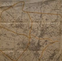
Scope & Content |
A 1916 map of Salem and the surrounding area that includes: Danvers, Peabody, Marblehead, Beverly and parts of Lynnfield. The map also shows the ward locations for Salem. The map was prepared and published for the Naumkeag Directory by Henry M. Meek Publishing Co. of Salem MA, but the copyright is from 1906 by Henry M. Meek. The circles show half mile distances from Salem City Hall. The 1916 edition was done by Walker Lith. & Publishing Company of Boston. |
Access Conditions |
Restricted to use in Sutton Room or Research Room. |
Physical characteristics |
paper |
Creator |
Henry M. Meek Publishing Company. |
Title |
1916 Map of Salem and Surrounding Places. |
Level of description |
Item |
Copyrights |
All copyrights belong to the Peabody Institute Library, Peabody, MA |
Collection |
Local History Resource Center |
Pub Date |
1916 |
Size |
53.2 x 71.6 cm |
Subjects |
Danvers (Mass.)--History--Map Salem (Mass.)--History--Map Beverly (Mass.)--History--Map Peabody (Mass.)--History--Map Marblehead (Mass.)--History--Map |
Parent ObjectID |
2015.36.2 |