
Archive Record
Images
Metadata
Catalog Number |
2003.26.1 |
Object Name |
Map |
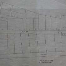
Scope & Content |
Plans shows the layout of Franklin Street;, Lowell Street and Kosciusko Street. The block is shown with property lines but thereis very little information about who owned the property of each lot. The map is 28 x 18" on starched linen paper. This is a duplicate of the orginal. It is unknown what happened to the original. It is unknown when the land was surveyed. The map was traced from the original by George A. Barnaby in March of 1928. Plan No. 44 |
Access Conditions |
Restricted to use in Sutton Room or Research Room. |
Physical characteristics |
Starched Linen. |
Creator |
George A. Barnaby |
Title |
Plan of Franklin Street; Lowell Street & Kosciusko Street |
Level of description |
Item |
Copyrights |
All copyrights belong to the Peabody Institute Library, Peabody, MA |
Collection |
Local History Resource Center |
Pub Date |
before 1882 |
Size |
28 x 18" |
Parent ObjectID |
2015.36.2 |