
Archive Record
Images
Metadata
Catalog Number |
2013.60.1 |
Object Name |
Map |
Scope & Content |
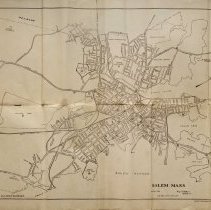
Map of Salem from March of 1923 that was created by Salem City Engineer and published by Crosby Publishing Co of Wollaston MA. The map has a listing of 33 locations throughout Salem that would be of interest to people. Some of the locations include: City Hall; Court House; Witch House; Proes Memorial; Public Library; Salem High Schoo; Salem Hospital; Gallows Hill Park; Ledge Hill Park; North Salem Playground; North Bridge; Bowdith School; Assembly Hall; Broad Street Playground; School Administration Building; Highland Park; Castle Hill Playground; Edwards Square Park; Lafayette Park; State Normal School; Peabody Museum; Essex Institute; State Armory; Derby Warh; Phillips School; House of Seven Gables; Bentley Schoo; Charter Street Cemetery; Broad Street Cemetery; Howard Street; Cemetery; Liberty Hill Park and Hotel Hawthorne among other locations. There is a note that says "Complete information in Guide Books available at Essex Institute and Stationary Stores." |
Access Conditions |
Restricted to use in Sutton Room or Research Room. |
Physical characteristics |
paper |
Creator |
Crosby Publishing Co. |
Title |
Map of Salem |
Level of description |
Item |
Copyrights |
All copyrights belong to the Peabody Institute Library, Peabody, MA |
Collection |
Local History Resource Center |
Pub Date |
1923 |
Size |
42.8 x 70.2 cm |
Subjects |
Salem (Mass.) Salem (Mass.)--Maps. |
Parent ObjectID |
2015.36.2 |