
Archive Record
Images
Metadata
Catalog Number |
2003.360.1 |
Object Name |
Map |
Scope & Content |
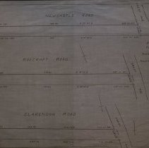
Map shows plan for Newcastle Rd. which parallels Gardner Street and is perpendicular to Abington Ave, Roycroft Rd. and Clarendon Rd. These are shown between Crest Ave. and Margin Street. The Clarendon Road on the map is present day Nelson Road. Crest Ave. is present day Walsh Ave. Lot numbers are shown on the map, but they do not correspond to anything within the collection. Frank Emerson, city engineer, conducted the survey in March of 1918 and the map was traced in April of 1929 by George A. Barnaby Plan No. 195 |
Creator |
City of Peabody |
Title |
City of Peabody Plan of Streets for Acceptance |
Level of description |
Item |
Copyrights |
All copyrights belong to the Peabody Institute Library |
Collection |
Local History Resource Center |
Pub Date |
1918 |
Size |
28 x 18" / 46 x 71.12 cm |
Subjects |
Peabody (Mass.)--History--Map(s) |
Parent ObjectID |
2015.36.2 |