
Archive Record
Images
Metadata
Catalog Number |
2016.36.20 |
Object Name |
Blueprint |
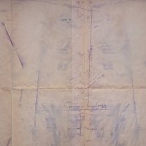
Scope & Content |
Site development plan of the land where the West Branch Library is. The plan was done by Easter Land Survey Associates, Inc. and Christopher R. Mello, P.L.'S. The scale is 1" = 20' and the survey was done on June 1, 1988. In the 1988 plans were started to look at building a new West Branch Library on the same piece of property that the old one sat on. An agreement and feasibility study was done in 1988 along with plans and City Council approval. In late 1988 the groundbreaking took place. There are three notes on the survey map. 1. This plan is the result of an on the ground field survey and public and private plans. 2. Utilities shown are based upon field survey and record plans and are not necessarily indicative of the underground conditions. 3. The contractor shall be responsible for verifying and determining the location, size and elevation of all existing utilities, shown of not shown on these plans, prior to any construction. The engineer shall be notified in writing of any utilities found interfering with the proposed construction and appropriate remedial action before proceeding with the work. Below that is a legend. |
Access Conditions |
Restricted to use in Sutton Room or Research Room. |
Creator |
Interact Archiecture Construction Management |
Title |
Survey of the West Branch Property |
Level of description |
Item |
Copyrights |
All copyrights belong to the Peabody Institute Library, Peabody, MA |
Collection |
Local History Resource Center |
Pub Date |
06/01/1988 |
Size |
24" x 36" |
Subjects |
Peabody Institute (Peabody, Mass.)--Construction or Blueprints Peabody Institute (Peabody, Mass.)--History Peabody Institute (Peabody, Mass.)--West Branch Library |
Parent ObjectID |
2014.31.1 |