
Archive Record
Images
Metadata
Catalog Number |
2005.124.64.2 |
Object Name |
Map |
Scope & Content |
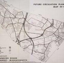
Community Facilities Map IV-1 Community Facilities Map !V-1 Map of City for the year 1968, including symbols for existing facilities and those that were being proposed. The information was based on maps of Peabody as of the October of 1968. The map was created in conjunction with Charles E. Downe who was a planning consultant located in Newton, MA. The preparation of the map was financed in part through an Urban Planning Grant from the Department of Housing and Urban Development. The Map shows freeways (proposed and proposed interchanges); arterials and collectors (existing, improved, proposed) and residential streets (existing). The map also shows the boundaries for Salem, Lynn, Lynnfield, Middleton and Danvers. |
Access Conditions |
Restricted to use in Sutton Room or Research Room. |
Physical characteristics |
Loose pages removed from notebook |
Creator |
City of Peabody Planning Board |
Other Creators |
Charles D. Downe |
Title |
Community Facilities Plan dn Capital Improvement Program for the City of Peabody |
Level of description |
Item |
Copyrights |
All copyrights belong to the Peabody Institute Library, Peabody, MA |
Collection |
Local History Resource Center |
Pub Date |
1962 |
Size |
19" x 23" |
Subjects |
Peabody--Growth Peabody--Planning Board Peabody--Zoning Map Peabody--Maps |
Parent ObjectID |
2015.36.2 |