
Archive Record
Images
Metadata
Catalog Number |
2003.163.2 |
Object Name |
Map |
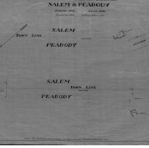
Scope & Content |
Plan shows border between Peabody and Salem. Streets on the map include: Beacon Street; Lark Street; Shillaber Street; Willow Street; Perpont Street; Charlotte Street; Osborne Street & Calumet Street. Homes are shown as dwellings and do not point out who lives there. This is a duplicate of the orginal. It is unknown what happened to the original. The land was surveyed on August of 1908. The map was traced from the original by George A. Barnaby in December of 1928. Plan No. 164 Sheet no. 1 |
Access Conditions |
Restricted to use in Sutton Room or Research Room. |
Physical characteristics |
Starched Linen Map |
Creator |
George A. Barnaby |
Title |
Plan of a Section of the Division Line Between Salem & Peabody |
Level of description |
Item |
Copyrights |
All copyrights belong to the Peabody Institute Library, Peabody, MA |
Collection |
Local History Resource Center |
Pub Date |
1908 |
Size |
28 x 18" |
Subjects |
Peabody (Mass.)--History--Map(s) |
Parent ObjectID |
2015.36.2 |