
Archive Record
Images
Metadata
Catalog Number |
2003.368.7 |
Object Name |
Map |
Scope & Content |
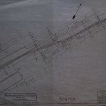
Plan shows location of Boston & Eastern Electric Railroad in Boston. The map shows a revised route through Boston. The section shows is 16 miles from Beverly. The maps shows an alternative line that cuts thought several streets and buildings in Boston. The new location of the B & R Railroad would run next to Bremen Street, cut through Summer street and then curve away from Marginal Street. The area on the map shows: Orleans Street; Summer Street; Bremen Street; Maverick Street; Lewis Street; Conard Steamship Co. Harbor Commissioners Ling the South Ferry and Marginal Street. The survey was done by John H. Bickford a Civil and Electrical Engineer who was located at 110 State Street in Boston. The map was first drawn by H.A.S. on October 1, 1906; The map was then traced by H.A.S. at an unknown date. This may be a duplicate because the map was retraced by George A. Barnaby in June of 1929. Plan No. 217 Sheet No. 5 Section No. 1 Total sheets 20 |
Access Conditions |
Restricted to use in Sutton Room or Research Room. |
Creator |
John H. Bickford |
Other Creators |
George A. Barnaby |
Title |
Boston and Eastern Electric Railroad -- Revised Route -- 16 Miles From Beverly |
Level of description |
Item |
Copyrights |
All copyrights belong to the Peabody Institute Library, Peabody, MA |
Collection |
Local History Resource Center |
Pub Date |
1907 |
Size |
18" x 28" |
Subjects |
Boston (Mass.) Boston (Mass.)--Maps Boston and Eastern Electric Railroad |
Parent ObjectID |
2015.36.2 |
Relation |
Show Related Records... |