
Archive Record
Images
Metadata
Catalog Number |
2003.135.2 |
Object Name |
Map |
Scope & Content |
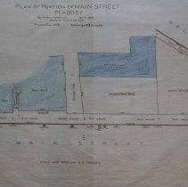
Maps shows one block of Main Street from Wallis Street west. Property on this map includes the Sutton's Brick Block; Sawyer's Brick Block a passage way, which is now a drive way for TD Bank, House No. 44; covered passage way; show and Brick House of Dr. C.B. Frothingham. The map also shows two crossing lans that were made using stone. Down the middle of the street was the Lynn and Boston Railroad tracks. This is a duplicate of the orginal. It is unknown what happened to the original. The land was surveyed by Charles A. Putnam on April 5th, 1894. The map was traced from the original by George A. Barnaby in December of 1928. One 28 x 18" Starched Linen Map. Plan No. 125 |
Access Conditions |
Restricted to use in Sutton Room or Research Room. |
Physical characteristics |
Starched Linen Map. |
Creator |
George A. Barnaby |
Title |
Plan of Portion of Main Street, Peabody |
Level of description |
Item |
Copyrights |
All copyrights belong to the Peabody Institute Library, Peabody, MA |
Collection |
Local History Resource Center |
Pub Date |
1894 |
Size |
28 x 18" |
Subjects |
Peabody (Mass.)--History--Map(s) |
Parent ObjectID |
2015.36.2 |