
Archive Record
Images
Metadata
Catalog Number |
2003.357.2 |
Object Name |
Map |
Scope & Content |
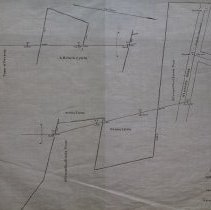
Map shows the line of probable construction between Northend and Gardner Streets for intercepting sewer. Roads on the map include: Gardner Street; Seneca Street; Northend Street and Newcastle Road. Property lines include: O'Connell Real Estate Trust; Mannix Estate; A.B. Clark Estate; and the Town of Peabody. George A. Barnaby was the engineer who conducted the first survey and the map was created in September of 1913. It is unknown what happened to the original. The map was traced by George A. Barnaby in April of 1929. Plan No. 180 |
Access Conditions |
Restricted to use in Sutton Room or Research Room. |
Physical characteristics |
Starched Linen Map |
Creator |
George A. Barnaby |
Title |
Intercepting Sewer between Northend Street to Gardner Street |
Level of description |
Item |
Copyrights |
All copyrights belong to the Peabody Institute Library, Peabody, MA |
Collection |
Local History Resource Center |
Pub Date |
1913 |
Size |
18" x 28" / 46 x 71.12 cm |
Subjects |
Peabody (Mass.)--History--Map(s) Mannix Clark, A. B. O'Connell |
Parent ObjectID |
2015.36.2 |
Relation |
Show Related Records... |