
Archive Record
Images
Metadata
Catalog Number |
2003.60.1 |
Object Name |
Map |
Scope & Content |
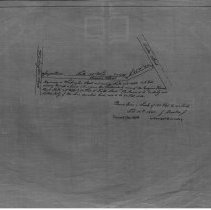
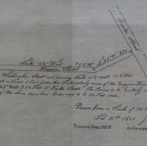
Plan of Mason Street that was surveyed in the winter of 1860. On map written: Beginning on Washington Street, and running North 15 1/2 degrees West 708 feet, Passing through a point 1 Foot from the Southeasterly corner of the Engine House, thence North 43 degrees West 230 Feet to Foster Street. The Road to be Easterly and Northeasterly of the above described lines, and to be 30 Feet Wide. This is a duplicate of the orginal. It is unknown what happened to the original. The land was surveyed by Joshua Buxton, Jr. on February 16th, 1860. The map was traced from the original by George A. Barnaby in December of 1928. One 28 x 18" Starched Linen Map. Plan No. 61 |
Access Conditions |
Restricted to use in Sutton Room or Research Room. |
Physical characteristics |
Starched Linen Map |
Creator |
George A. Barnaby |
Other Creators |
Joshua Buxton, Jr. |
Title |
Plan of Mason Street. |
Level of description |
Item |
Copyrights |
All copyrights belong to the Peabody Institute Library, Peabody, MA |
Collection |
Local History Resource Center |
Pub Date |
1860 |
Size |
28 x 18" |
Subjects |
Peabody (Mass.)--History--Map(s) |
Parent ObjectID |
2015.36.2 |