
Archive Record
Images
Metadata
Catalog Number |
2003.133.1.E |
Object Name |
Map |
Scope & Content |
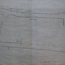
Map shows Lynnfield Street from Stella Newhall's residence to John Mansfield's residence. The blue lines indicating survey by Nichols may be John H. Nichols who drew many maps in the 1840's. This is a duplicate of the orginal. It is unknown what happened to the original. The land was surveyed by James A. Bancroft on November 20th, 1897. The map was traced from the original by George A. Barnaby in March of 1928. One 28 x 18" Starched Linen Map. Plan No. 119 Sheet No. 5 Note: Total sheets 6 |
Access Conditions |
Restricted to use in Sutton Room or Research Room. |
Physical characteristics |
Starched Linen Map. |
Creator |
George A. Barnaby |
Title |
Plan of Lynnfield Street in Peabody, Mass. |
Level of description |
Item |
Copyrights |
All copyrights belong to the Peabody Institute Library, Peabody, MA |
Collection |
Local History Resource Center |
Pub Date |
1897 |
Size |
28 x 18" |
Subjects |
Peabody (Mass.)--History--Map(s) |
Parent ObjectID |
2015.36.2 |