
Archive Record
Images
Metadata
Catalog Number |
2002.767.2 |
Object Name |
Map |
Scope & Content |
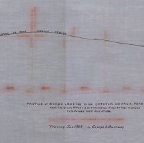
One 28 x 18" starched linen map shows surface of roads leading to the Catholic Church. The survey was done on June 9, 1886 by Charles A. Putnam and the map was created in January of 1928 |
Access Conditions |
Restricted to use in Sutton Room or Research Room. |
Creator |
George A. Barnaby traced map January 1928 |
Title |
Profile of Roads Leading to the Catholic Church, Peabody. |
Level of description |
Item |
Copyrights |
All copyrights belong to the Peabody Institute Library |
Collection |
Local History Resource Center |
Pub Date |
1886 |
Size |
28 x 18" |
Subjects |
Peabody (Mass.)--History--Map Peabody (Mass.)--Streets |
Parent ObjectID |
2015.36.2 |