
Archive Record
Images
Metadata
Catalog Number |
2003.57.1 |
Object Name |
Map |
Scope & Content |
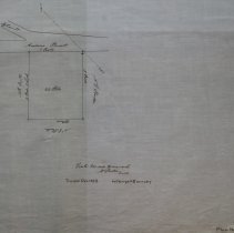
A mape of the Peabody's Gravel Pit near Proctor's from 1854. The property was located off Andover Street. This is a duplicate of the orginal. It is unknown what happened to the original. The map was traced from the original by George A. Barnaby in December of 1928. One 28 x 18" Starched Linen Map. Plan No. 58 |
Access Conditions |
Restricted to use in Sutton Room or Research Room. |
Physical characteristics |
Starched Linen Map |
Creator |
George A. Barnaby |
Title |
Map of Town's Gravel Pit near Procter's from 1854 |
Level of description |
Item |
Copyrights |
All copyrights belong to the Peabody Institute Library, Peabody, MA |
Collection |
Local History Resource Center |
Size |
28 x 18" |
Subjects |
Peabody (Mass.)--History--Map(s) |
Parent ObjectID |
2015.36.2 |