
Archive Record
Images
Metadata
Catalog Number |
2003.360.2 |
Object Name |
Map |
Scope & Content |
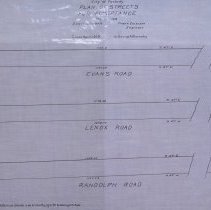
Plan shows plan for Evans Road, Lenox Road and Randolph Road, which is present day Nickerson Road, located between Margin Street and Abington Ave. The map shows lot numbers, but there is nothing in the collection that corresponds with these numbers. It is possible that these lots were to be sold. Frank Emerson, city engineer, did the survey in March of 1918 and the map was traced in April of 1929 by George A. Barnaby. Plan No. 196 |
Access Conditions |
Restricted to use in Sutton Room or Research Room. |
Creator |
City of Peabody |
Title |
City of Peabody Plan of Streets for Acceptance |
Level of description |
Item |
Copyrights |
All copyrights belong to the Peabody Institute Library, Peabody, MA |
Collection |
Local History Resource Center |
Pub Date |
1918 |
Size |
28 x 18" / 46 x 71.12 cm |
Subjects |
Peabody (Mass.)--History--Map(s) |
Parent ObjectID |
2015.36.2 |