
Archive Record
Images
Metadata
Catalog Number |
2003.368.19 |
Object Name |
Map |
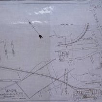
Scope & Content |
Plan shows location of the Boston and Eastern Electric Railroad in Revere. The map shows: Kimball Avenue; Walnut Avenue; Beach Street; Brewster Street; Otis Street; Wonderland Park; Tapley Street; County Ditch; Proposed Sewer; Boston & Main Railroad; Marsh Line; Bath Street; Revere Beach Parkway; Atlantic Ocean; Beaver Street; Ocean Avenue; Baker Avenue; Bryant Street; Stowers Street; Tuttle Street; George Street; Pomona Street; Revere Street and Folsom Street. The survey was done by John H. Bickford a Civil and Electrical Engineer who was located at 110 State Street in Boston. The map was first drawn by H.A.S. on April 5, 1907; The map was then traced by H.A.S. at an unknown date. This may be a duplicate because the map was retraced by George A. Barnaby in June of 1929. Plan No. 217 Sheet No. 2 Total sheets 20 |
Access Conditions |
Restricted to use in Sutton Room or Research Room. |
Creator |
John H. Bickford |
Title |
Boston and Eastern Electric Railroad -- Revere Beach Loop |
Level of description |
Item |
Copyrights |
All copyrights belong to the Peabody Institute Library, Peabody, MA |
Collection |
Local History Resource Center |
Pub Date |
1906 |
Size |
46 x 71.12 cm |
Subjects |
Revere (Mass.) Revere (Mass.)--Maps Boston and Eastern Electric Railroad |
Relation |
Show Related Records... |