
Archive Record
Images
Metadata
Catalog Number |
2003.393.1.D |
Old ID number |
2003.393.5 |
Object Name |
Map |
Scope & Content |
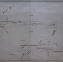
Maps show the plans for the Newburyport Turnpike as it became a state highway in the year 1920 The survey was done by the Commonwealth of Massachusetts on May 24, 1920. It is unknown what happened to the original. This copy was traced by George A. Barnaby in July of 1929. Plan No. 238 Sheet No. 5 Note: Total Sheets, 12 |
Access Conditions |
Restricted to use in Sutton Room or Research Room. |
Creator |
Commonwealth of Massachusetts |
Title |
Commonwealth of Massachusetts Plan of Road in the City of Peabody, Essex County Laid out as a State Highway by the Department of Public Works |
Level of description |
Item |
Copyrights |
All copyrights belong to the Peabody Institute Library, Peabody, MA |
Collection |
Local History Resource Center |
Pub Date |
1920 |
Size |
46 x 71.12 cm |
Subjects |
Peabody (Mass.)--History--Map(s) |
Parent ObjectID |
2015.36.2 |