
Archive Record
Images
Metadata
Catalog Number |
2004.284.1 |
Object Name |
Map |
Scope & Content |
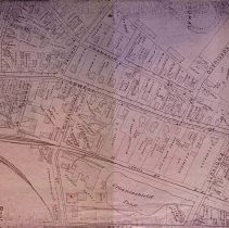
Map of downtown Peabody from the circa 1890s that is similar to the Sanborn Insurance Maps. This maps shows the streets, and locations of buildings and houses along with who owned them at the time. The map also provides the house numbers of the area. This photocopy of the original map shows. Perkins Street; School Street; Lowell Street; Railroad Aveune; Sawyer Street; Crowninshield Street; Endicott Street; and Kosciusco Street. In addition, the map also shows the location of the Lowell Boston and Maine Railroad. Crowninshield Pond, the Ice House and power station are shown on the map. |
Access Conditions |
Restricted to use in Sutton Room or Research Room. |
Physical characteristics |
Blue print maps. |
Creator |
Unknown |
Title |
Central Peabody, c. 1890's. |
Level of description |
Item |
Copyrights |
All copyrights belong to the Peabody Institute Library, Peabody, MA |
Collection |
Local History Resource Center |
Pub Date |
c. 1890's |
Size |
11" x 17" |
Parent ObjectID |
2015.36.2 |
Relation |
Show Related Records... |