
Archive Record
Images
Metadata
Catalog Number |
2002.761.1.A |
Object Name |
Map |
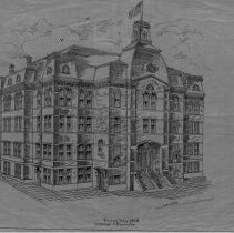
Scope & Content |
28 x 18" Starched Linen Map of the Plan of Peabody Town Hall showing the exterior view from the corner of Lowell and Chestnut Street. The drawing shows the outside of the building as it appeared upon its completion. It is unlear where the original is, but this map was traced by George A. Barnaby in May of 1928. Plan No. 9 Sheet No. 1 |
Access Conditions |
Restricted to use in Sutton Room or Research Room. |
Physical characteristics |
Starched linen map. |
Creator |
George A. Barnaby |
Title |
Plan Of Town Hall. |
Level of description |
Item |
Copyrights |
All copyrights belong to the Peabody Institute Library, Peabody, MA |
Collection |
Local History Resource Center |
Pub Date |
1928 |
Size |
28 x 18" ; 46 x 71.12 cm |
Subjects |
Peabody (Mass.)--History--Map(s) |
Parent ObjectID |
2015.36.2 |
Relation |
Show Related Records... |