
Archive Record
Images
Metadata
Catalog Number |
2016.83.78 |
Object Name |
Map |
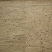
Scope & Content |
Map of Peabody created in 1931. The map was created by Osborn Palmer, Engineer. The map was gridded, to allow the engineer to create further maps of each gridded area. Civil Engineer, Osborne Palmer, lived at 171 Lowell Street and had his own firm, which was located at 15 Wallis Street in Peabody. Streets include: Corwin Street Way Lynnfield Street Craig's Pond Goldthwaite Brook Property & Landmarks: Harry Krochmal A. Foster Raddin Mary A. Hames Henry L. Cawley Florence Harvie Charles Fraggos Alexander Smith Charles Chandler William Powell Hannah E. Newhall Stephen Voymas Sarah A. Lake Caroline M. Marcou Annie M. Holleran Sarah A. Greene Isabel S. Southwick John A. Telford Carriel Cawley Massachsuetts Hair and Felt Co. A. Foster Raddin Densten Hair Co. Pendelis G. Thiakos Underwriters Salvage Co. William Wolloff Herbert J. Pease, et. als Boston & Maine Railroad N 13 |
Access Conditions |
Property of the Peabody Institute Library, Peabody, MA |
Creator |
Unknown |
Title |
Map of Peabody - N13 - 1931 |
Level of description |
Item |
Copyrights |
COPYRIGHT UNDETERMINED The copyright and related rights status of this Item has been reviewed by the organization that has made the Item available, but the organization was unable to make a conclusive determination as to the copyright status of the Item. Please refer to the organization that has made the Item available for more information. You are free to use this Item in any way that is permitted by the copyright and related rights legislation that applies to your use. NOTICES Unless expressly stated otherwise, the organization that has made this Item available makes no warranties about the Item and cannot guarantee the accuracy of this Rights Statement. You are responsible for your own use. You may find additional information about the copyright status of the Item on the website of the organization that has made the Item available. You may need to obtain other permissions for your intended use. For example, other rights such as publicity, privacy or moral rights may limit how you may use the material. |
Collection |
Local History Resource Center |
Pub Date |
1931 |
Size |
30 x 42.5 inches |
Subjects |
Peabody (Mass.)--History--Map(s) Peabody (Mass.)--Streets |
Parent ObjectID |
2015.36.2 |