
Archive Record
Images
Metadata
Catalog Number |
2002.777.1 |
Object Name |
Map |
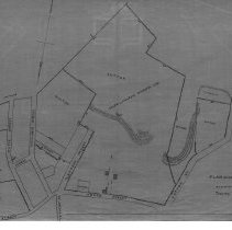
Scope & Content |
This 28 x 18" starched linen map shows the streets around Salem / Peabody Boundary in 1884. It is unclear as to which Sutton owned much of the land around this area. The streets shown include: Sutton Street; Aborn Street; Pierpont Street; Shillaber Street; Maple Street and Bow Street. There is also a gravel pit near the H. Ayer's Estate. Charles A. Putnam did the survey on February 27, 1884. This is a duplicate of the original. The map was traced by George A. Barnaby in March of 1928 |
Access Conditions |
Restricted to use in Sutton Room or Research Room. |
Physical characteristics |
Starched Linen Map |
Creator |
George A. Barnaby |
Title |
Plan Showing the Salem and Peabody Boundary Line, Between Aborn And Sutton Streets. |
Level of description |
Item |
Copyrights |
All copyrights belong to the Peabody Institute Library, Peabody, MA |
Collection |
Local History Resource Center |
Pub Date |
1884 |
Size |
28 x 18" |
Subjects |
Peabody (Mass.)--History--Map |
Parent ObjectID |
2015.36.2 |