
Archive Record
Images
Metadata
Catalog Number |
2003.368.17 |
Object Name |
Map |
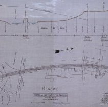
Scope & Content |
Plan shows location of the Boston & Eastern Electric Railroad in Revere. The top of the map shows the elevation and grade of the proposed railroad. The bottom is a map that shows: Pleasant Street; Town Hall; Broadway; Old Route to Sullivan Square; Hyde Street; Cheever Street; Beach Street; Eaton Street; Revere Beach Parkway; Metropolitan Park; Mill Creek; Clinton Street; Revere boundary and the Chelsea Boundary. The survey was done by John H. Bickford a Civil and Electrical Engineer who was located at 110 State Street in Boston. The map was first drawn by H.A.S. on October 1, 1906; The map was then traced by H.A.S. at an unknown date. This may be a duplicate because the map was retraced by George A. Barnaby in June of 1929. Plan No. 217 Sheet No. 13 Total sheets 20 |
Access Conditions |
Restricted to use in Sutton Room or Research Room. |
Creator |
John H. Bickford |
Other Creators |
George A. Barnaby |
Title |
Boston and Eastern Electric Railraod -- Revised Route -- 13 Miles from Beverly |
Level of description |
Item |
Copyrights |
All copyrights belong to the Peabody Institute Library, Peabody, MA |
Collection |
Local History Resource Center |
Pub Date |
1907 |
Size |
46 x 71.12 cm |
Subjects |
Revere (Mass.) Revere (Mass.)--Maps Boston and Eastern Electric Railroad |
Parent ObjectID |
2015.36.2 |
Relation |
Show Related Records... |