
Archive Record
Images
Metadata
Catalog Number |
2002.770.1 |
Object Name |
Map |
Scope & Content |
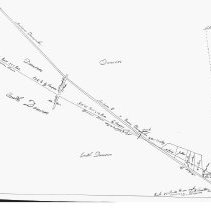
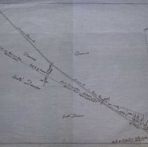
One 28 x 18" starched linen map that shows division line between Danvers and South Danvers at the Andover Turnpike (Route 114). The map was created circa 1856 but this map was not drawn until 1928 by George A. Barnaby, the surveyor is unknown. |
Access Conditions |
Restricted to use in Sutton Room or Research Room. |
Creator |
George A. Barnaby |
Title |
Plan of Division Line between Danvers and South Danvers. |
Level of description |
Item |
Copyrights |
All copyrights belong to the Peabody Institute Library, Peabody, MA |
Collection |
Local History Resource Center |
Pub Date |
1856? |
Size |
28 x 18" |
Subjects |
Peabody (Mass.)--History--Map Peabody (Mass.)--History--Map--Andover Street |
Parent ObjectID |
2015.36.2 |