
Archive Record
Images
Metadata
Catalog Number |
2016.83.85 |
Object Name |
Map |
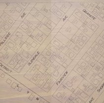
Scope & Content |
Map of Peabody created in 1931. The map was created by Osborn Palmer, Engineer. The map was gridded, to allow the engineer to create further maps of each gridded area. Civil Engineer, Osborne Palmer, lived at 171 Lowell Street and had his own firm, which was located at 15 Wallis Street in Peabody. Streets include: Lake Shore Road Granite Road Fairview Avenue Detroit Street Bay State Road Glendale Avenue Hillside Avenue Property & Landmarks: Brown's Pond Frank H. Hearan John C. Stone Louis H. Bonelli, Jr. Guy L. Moffett Bertha Brooks Mildred L. McIntire Clarence Bailey Lester D. Mathews Emily L. Gregory Kenneth M. Rose Herbert D. Floyd Mellie F. Watkins James R. Berryman George Quimby Margaret Olliver Arthur J. Mathews Rosella Bergeron Frank A. Lufkin Fred B. Forristal Morris C. Bangs William Morrison Harlan E. Day Myles T. Moran Edward Gilblair Leroy Herron Sadie B. Fowler Emily Gregory Matilda Barlow Charles Ward John C. Bowen Zoe M. Weil Stella MacRae Maud E. MacNeal Mildred C. Guilleford Percy O. Parshley E.C. Phillips, Inc. Grank Guertin Sarah J. Waring Cecil G.S. Young Francis Donnell Irving Beane Rose A. Walsh William Ganter Sidney W. Burke J. Frank Perkins Carl G.A. Nelson Mary E. Abbott Samuel Knight, et. als. Eva M. Dalton William Corbett Sara A. Rainford Annie Berman Harold Schaffer Charles C. Thurlow Evangeline Rooney James M. Norton Philip W. Bourgeois Nellie M. Parker Alice M. Parker Ethell Holden E.E. Whipple Lillian I. Richardson Principio Romano Herbert S. Clough Sarah J. Waring Katherine Hemenway Henry M. Bumps Mary D. Gould Louise E. Bourgeois Harry E. Swift Rose Samuelson N 20 |
Access Conditions |
Property of the Peabody Institute Library, Peabody, MA |
Creator |
Unknown |
Title |
Map of Peabody - N20 - 1931 |
Level of description |
Item |
Copyrights |
COPYRIGHT UNDETERMINED The copyright and related rights status of this Item has been reviewed by the organization that has made the Item available, but the organization was unable to make a conclusive determination as to the copyright status of the Item. Please refer to the organization that has made the Item available for more information. You are free to use this Item in any way that is permitted by the copyright and related rights legislation that applies to your use. NOTICES Unless expressly stated otherwise, the organization that has made this Item available makes no warranties about the Item and cannot guarantee the accuracy of this Rights Statement. You are responsible for your own use. You may find additional information about the copyright status of the Item on the website of the organization that has made the Item available. You may need to obtain other permissions for your intended use. For example, other rights such as publicity, privacy or moral rights may limit how you may use the material. |
Collection |
Local History Resource Center |
Pub Date |
1931 |
Size |
30 x 42.5 inches |
Subjects |
Peabody (Mass.)--History--Map(s) Peabody (Mass.)--Streets |
Parent ObjectID |
2015.36.2 |