
Archive Record
Images
Metadata
Catalog Number |
2002.709.4 |
Object Name |
Map |
Scope & Content |
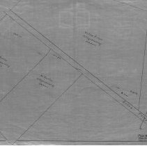
One 28 x 18" map, Plan 2, Sheet No. 4 of the plans showing the location Of The Division Line Between Danvers And South Danvers fin 1856. The map was traced by George A. Barnaby in 1929. The map includes the Essex Turnpike; R.C. Fletcher; N. Felton tillage and mowing; M. Preston tillage & mowing; the Wilson Estate tillage & mowing (26 1/4 acres); Price tillage and Buxton. |
Access Conditions |
Restricted to use in Sutton Room or Research Room. |
Creator |
George A. Barnaby traced map August 1929 |
Title |
Location Of The Division Line Between Danvers And S. Danvers |
Level of description |
Item |
Copyrights |
All copyrights belong to the Peabody Institute Library |
Collection |
Local History Resource Center |
Pub Date |
1856 |
Size |
28 x 18" |
Subjects |
Peabody (Mass.) - Maps Peabody (Mass.) - Boundaries |
Parent ObjectID |
2015.36.2 |