
Archive Record
Images
Metadata
Catalog Number |
2003.393.1.K |
Old ID number |
2003.393.12 |
Object Name |
Map |
Scope & Content |
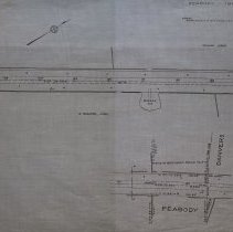
Maps show the plans for the Newburyport Turnpike as it became a highway in the year 1920. The map shows the where the Peabody and Danvers line is in relations to the Newburyport Turnpike. Property and landmarks include: Agustus Fisher; William Loony; G. Moulton, Admr. and Barrow Pit. |
Access Conditions |
Restricted to use in Sutton Room or Research Room. |
Creator |
Commonwealth of Massachusetts |
Title |
Commonwealth of Massachusetts Plan of Road in the City of Peabody, Essex County Laid out as a State Highway by the Department of Public Works |
Level of description |
Item |
Copyrights |
All copyrights belong to the Peabody Institute Library, Peabody, MA |
Collection |
Local History Resource Center |
Pub Date |
1920 |
Size |
46 x 71.12 cm |
Subjects |
Peabody (Mass.)--History--Map(s) |
Parent ObjectID |
2015.36.2 |