
Archive Record
Images
Metadata
Catalog Number |
2003.366.1 |
Object Name |
Map |
Scope & Content |
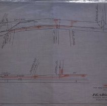
Plan shows positions of old conduits and probable location of new conduit on Lowell and Central Streets. The other strees on the map include: Elm Street; Strevens Street; Hardy Street' Elm Place; Walnut Street; Church Street; Passage Way and School Street. The Boston & Maine Railroad is also shown on the map. The red area is the preliminary plan. It should be noted that Passage Way on Map appears to be present day St. John's Ave.; Church Street on Map seems to be present day Chestnut Street and Elm Place on map is present day Munroe Court. It is unknown who did the survey, but the map was traced in May of 1929 by George A. Barnaby. Plan No. 215 |
Access Conditions |
Restricted to use in Sutton Room or Research Room. |
Creator |
N. E. Tel. and Tel. Co. of Mass. |
Title |
Preliminary Plan by New England Telephone and Telegraph Co. of Massachusetts of Conduit in Peabody, Mass. |
Level of description |
Item |
Copyrights |
All copyrights belong to the Peabody Institute Library, Peabody, MA |
Collection |
Local History Resource Center |
Size |
28 x 18" / 46 x 71.12 cm |
Subjects |
Peabody (Mass.)--History--Map(s) |
Parent ObjectID |
2015.36.2 |