
Archive Record
Images
Metadata
Catalog Number |
2002.729.1 |
Object Name |
Map |
Scope & Content |
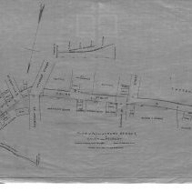
"Plan of Portion of Aborn Street, In Salem and Peabody." The map is 18 x 28" and details Aborn and Pierpont Streets. The land was surveyed in July of 1883 by Charles A. Putnam. The survey would be turned into a map in January 1928 by George A. Barnaby who traced the map. The map shows Aborn with several street connecting to it. They include: Sutton Street; Pleasant Street; Pierpont Street; Shillaber Street and Maple Steet. The Sutton's had a lot of land and house on Aborn Street. The house belonged to William Sutton, who is related to Eben Sutton. There was also a Warren Bank and several other houses. Plan No. 6, Sect. A. |
Access Conditions |
Restricted to use in Sutton Room or Research Room. |
Physical characteristics |
Starched linen map. |
Creator |
George A. Barnaby |
Title |
Plan of Portion of Aborn Street, In Salem and Peabody. |
Level of description |
Item |
Copyrights |
All copyrights belong to the Peabody Institute Library. |
Collection |
Local History Resource Center |
Pub Date |
1928 |
Size |
28 x 18" |
Subjects |
Peabody (Mass.) - Maps |
Parent ObjectID |
2015.36.2 |