
Archive Record
Images
Metadata
Catalog Number |
2003.368.6 |
Object Name |
Map |
Scope & Content |
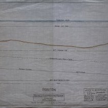
Plan shows location of the Boston & Eastern Electric Railroad in Boston. The plan shows railroad going under ground. The vertical scale is 1 inch = 10 feet. The mean is high water. Then the Boston City base; sea floor; 40 ft dredging line' the approximate line of the roof of the tunnel. There would be a 3% grade for the proposed railroad moving to a .50% grade then 1.52% grade going up. The side view is 30 feet below Boston City base. The survey was done by John H. Bickford a Civil and Electrical Engineer who was located at 110 State Street in Boston. The map was first drawn by H.A.S. on October 1, 1906; The map was then traced by H.A.S. at an unknown date. This may be a duplicate because the map was retraced by George A. Barnaby in June of 1929. Plan No. 217 Sheet No. 4 Section 2 Total sheets 20 |
Access Conditions |
Restricted to use in Sutton Room or Research Room. |
Creator |
John H. Bickford |
Title |
Boston and Eastern Electric Railroad -- Revised Route -- 16 1/2 Miles From Beverly |
Level of description |
Item |
Copyrights |
All copyrights belong to the Peabody Institute Library, Peabody, MA |
Collection |
Local History Resource Center |
Pub Date |
1906 |
Size |
18" x 28" |
Subjects |
Boston (Mass.) Boston (Mass.)--Maps Boston and Eastern Electric Railroad |
Parent ObjectID |
2015.36.2 |
Relation |
Show Related Records... |