
Archive Record
Images
Metadata
Catalog Number |
2003.55.1 |
Object Name |
Map |
Scope & Content |
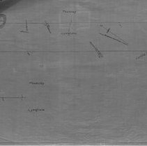
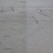
Plan shows area and boarder that Peabody has with Lynnfield. The map shows Humprey's Pond or Suntaug Lake and two railroads. There is also an unknow pond bthat is between Peabody and Lynnfield. This is a duplicate of the orginal. It is unknown what happened to the original. The land was surveyed by James A. Bancroft on June 20th, 1894. The map was traced from the original by George A. Barnaby in March of 1928. One 28 x 18" Starched Linen Map. Plan No. 55 |
Access Conditions |
Restricted to use in Sutton Room or Research Room. |
Physical characteristics |
Starched Linen Map |
Creator |
George A. Barnaby |
Other Creators |
James A. Bancroft |
Title |
Reading of West Peabody. |
Level of description |
Item |
Copyrights |
All copyrights belong to the Peabody Institute Library, Peabody, MA |
Collection |
Local History Resource Center |
Pub Date |
1894 |
Size |
28 x 18" |
Subjects |
Peabody (Mass.)--History--Map(s) |
Parent ObjectID |
2015.36.2 |