
Archive Record
Images
Metadata
Catalog Number |
2002.760.1 |
Object Name |
Map |
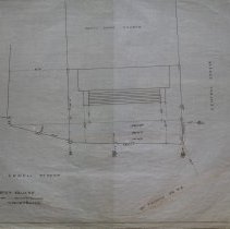
Scope & Content |
This 13" x 28 1/2" shows a portion of Peabody Square at the corner of Lowell and Central Streets. The South Congregational Church and B.F. Hutchingson property are shown on the map. The South Reading Railroad runs at an angle to Lowell and Central Streets. In addition, there are four elm trees shown on the map. The map is plan number 8. Charles A. Putnam and was suvyor and was done on March 18, 1884 and George A. Barnaby did the plan/map in January of 1928. |
Access Conditions |
Restricted to use in Sutton Room or Research Room. |
Physical characteristics |
One paper map. |
Creator |
George A. Barnaby |
Title |
Portion Of Peabody Square |
Level of description |
Item |
Copyrights |
All copyrights belong to the Peabody Institute Library, Peabody, MA |
Collection |
Local History Resource Center |
Pub Date |
1884 |
Size |
13" x 28 1/2" |
Subjects |
Peabody (Mass.)--History--Map(s) |
Parent ObjectID |
2015.36.2 |
Outside Links |
Portion Of Peabody Square |