
Archive Record
Images
Metadata
Catalog Number |
2003.3.1 |
Object Name |
Map |
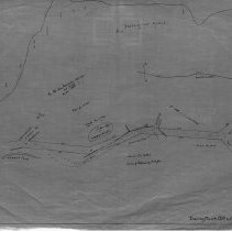
Scope & Content |
One 28 x 18" starched linen map of the road leading from Lowell Street to what was once known as West Street, the present day Johnson Street. Upham's Pond is shown on the map. This is a duplicate of the orginal. This map was traced by George A. Barnaby in March of 1928. |
Access Conditions |
Restricted to use in Sutton Room or Research Room. |
Physical characteristics |
Starched Linen Map |
Creator |
George A. Barnaby |
Title |
Plan of proposed way leading from Lowell Street to West Street, Peabody |
Level of description |
Item |
Copyrights |
All copyrights belong to the Peabody Institute Library, Peabody, MA |
Collection |
Local History Resource Center |
Pub Date |
1890? |
Size |
28 x 18" |
Subjects |
Peabody (Mass.)--History--Map(s) |
Parent ObjectID |
2015.36.2 |