
Archive Record
Images
Metadata
Catalog Number |
2003.368.4 |
Object Name |
Map |
Scope & Content |
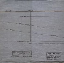
Plan shows location of Boston & Eastern Electric Railroad in Boston. The plan shows the grade (vertical scale 1" = 10') of Inda Square; Central Street and Atlantic Avenue. A dotted line shows the approximate line of roof of the tunnel that would go under the street. The view is 70 feet below Boston. The survey was done by John H. Bickford a Civil and Electrical Engineer who was located at 110 State Street in Boston. The map was first drawn by H.A.S. on October 1, 1906; The map was then traced by H.A.S. at an unknown date. This may be a duplicate because the map was retraced by George A. Barnaby in June of 1929. Plan No. 217 Sheet No. 3 Section No. 2 Total sheets 20 |
Access Conditions |
Restricted to use in Sutton Room or Research Room. |
Creator |
John H. Bickford |
Other Creators |
George A. Barnaby |
Title |
Boston and Eastern Electric Railroad -- Revised Route -- Atlantic Ave. Section |
Level of description |
Item |
Copyrights |
All copyrights belong to the Peabody Institute Library, Peabody, MA |
Collection |
Local History Resource Center |
Pub Date |
1906 |
Size |
18" x 28" |
Subjects |
Boston (Mass.) Boston (Mass.)--Maps Boston and Eastern Electric Railroad |
Parent ObjectID |
2015.36.2 |
Relation |
Show Related Records... |