
Archive Record
Images
Metadata
Catalog Number |
2002.728.2 |
Object Name |
Map |
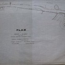
Scope & Content |
Plan of Highway in Peabody leading from Brookdale Crossroads to Southwick's Corner showing proposed alterations. Land was surrveyed on October 29th, 1873 and the by A & L.A. Nichols Surveyors. The map was traced in February of 1928 by George A. Barnaby. The map is 18 x 28" detailing property around Mill Pond, including direction of Middleton Paper Mills, Pine Street, Wyona Street and Brown property. Plan No. 5. Section B. |
Access Conditions |
Restricted to use in Sutton Room. |
Physical characteristics |
Starched linen map. |
Creator |
George A. Barnaby |
Title |
Plan of Highway in Peabody Leading from Brookdale Crossroads to Southwick's Corner, Showing Proposed Alterations. |
Level of description |
Item |
Copyrights |
All copyrights belong to the Peabody Institute Library. |
Collection |
Local History Resource Center |
Pub Date |
1928 |
Size |
28 x 18" |
Subjects |
Peabody (Mass.) - Maps |
Parent ObjectID |
2015.36.2 |