
Archive Record
Images
Metadata
Catalog Number |
2003.359.2 |
Old ID number |
2003.359 |
Object Name |
Map |
Scope & Content |
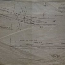
Plans for widening Gardner Street with the intention for future development of what had once been Gardner Farm. The map shows the at the time location of fire hydrants; poles and trees before the street was widened. There is a note that reads: dotted line represents present street line. Full line represents proposed street line. During the year 1912 the Gardner farm passed into the ownership of the O'Connell Real Estate Trust, promoters who laid out the land for homes. The road was then widened and became known as Gardner Park. Proposed roads appear to be present day Abington Ave. and Seneca Rd. The mpa was done by O. Willis Rugg, engineer in 1912. It is unknown where the original is. The map was traced by George A. Barnaby in April of 1929. Plan No. 194 |
Access Conditions |
Restricted to use in Sutton Room or Research Room. |
Physical characteristics |
Starched Linen Map |
Creator |
O. Willis, Engineer and George A. Gleason, Resident Engineer of Peabody |
Title |
Plan Showing Proposed Widening of Gardner Street As Petitioned for by the O'Connell Real Estate Trust. |
Level of description |
Item |
Copyrights |
All copyrights belong to the Peabody Institute Library, Peabody, MA |
Collection |
Local History Resource Center |
Pub Date |
1911 |
Size |
18" x 28" / 46 x 71.12 cm |
Subjects |
Peabody (Mass.)--History--Map(s) Jacobs, William H. |
Parent ObjectID |
2015.36.2 |